Long Beach - Ucluelet Topo Map
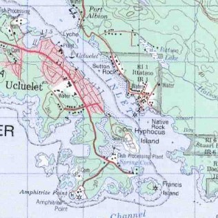
Long Beach - Ucluelet, Vancouver Island BC
This topographic map covers:
- Long Beach
- Pacific Rim National Park
- Ucluelet
- Ucluth Peninsula
- Vancouver Island
- Ucluelet Inlet
- Sea Lion Rocks
- Florencia Bay
- Green Point
- Box Island
- Wickannish Bay
- Radar Hill
- Mount Dawley
- Salmonberry Mountain
- Kennedy Lake
- Mount Frederick
- Mount Ozzard
- Port Albion
- Hyphocus Island
- Francis Island
Maps near Long Beach - Ucluelet, BC


 by")


Long Beach - Ucluelet, Vancouver Island, BC